
|
MAPEINES 8 |
version 8.04 - january/2010 ( 0.19 Mb).
Invert Surfer color spectrum
version 8.0 - may/2009 ( 0.19 Mb).
BNA ( opcionally +CSV ) > XML
Metadata from CSV file are add to XML file
version 7.8 - sep/2008 ( 0.19 Mb).
BNA > HYPACK TARGET LINES
version 7.7.4 - Feb/2007 ( 0.19 Mb).
Bug on filtering big files removed
CORRECTED COLORS BUG of Google Earth transformation
version 7.7.2 - Nov/2006 ( 0.19 Mb).
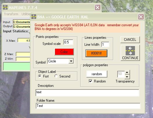
BNA > KML GOOGLE EARTH
BNA => VEC (MIRAMON GIS)
version 7.63 - 28/June/2006 ( 0.18 Mb).
CSV (x,y,cdp) > Kingdonsuite navigation file
BNA > SIS (Simrad) Ascciplan
Surfer color palette > Miramon (GIS) 256 color palette
New in the 7.5. version:
Draws a BNA circle.
transforms BNA (Surfer) from and to VEC (Miramon GIS).
Extracts grids from Surfer maps (ascci and binary)
Download last version : MAPEINES.zip
Mapeines V.7.7 - manual
1. TRANSFORM
1.1 BNA => XY(Z) Transform a bna file with format like: "z1","z2",1,x,y (single point bna)
or format ( lines bna) like:
"z1","z2",n
x1,y1
...
xn,yn"
to a file with format xyz, yxz, xy o yx where z could be "z1" or " z2" numeric value
1.2 LÍNES BNA => POINTS BNA Transform lines bna format file to single points bna format
1.3 GEBCO => GMT Transform a file generated by Gebco Digital Atlas Export ASCII Function to GMT import ascii format.
1.4 GEBCO (97 and centennial versions) => XYZ transform a file generated by Gebco Digital Atlas Export ASCII Function to xyz triplets
1.5 GEBCO (97 and centennial versions) => BNA Transform a file generated by Gebco Digital Atlas Export ASCII Function to BNA Lines
1.6 XYZ => BNA Opposite function of 1.1
1.7 XYZ => GMT Transform a XYZ triplets file to GMT. X and Y can be interchanged
1.8 XYZ => XY(Z) Change the position of X and Y columns and Z. You can change de separator character and has de possibility to add two more columns with partial and accumulated distances-
1.9 BNA => MERLIN(Simrad) A Planning for Merlin can be generated from a BNA. The option "Coastline" doesn’t work is and is not activated.
1.10 BNA =>GEOSAIL(Planning) Generates a Geosail Plan file from a BNA file.
1.11 BNA => BRIDGE PLAN. Transform a bna file to a list of points in degrees and minutes of arc. he result is expressed in latitude and longitude.
1.12 UKOOA => BNA Transform a UKOOA to a BNA file. This file (Ukooa) can be obtained processing multibeam by Neptune (Simrad software). The generated file has one position each second. The program permits to extract positions at regular time intervals for fix points and for label points
1.13 IRAP_GEOASCII => XYZ Change the format generated by IRAP-Geosea, geographic ASCII. (Degrees, minutes, seconds, degrees, minutes, seconds, meters) to decimal degrees, meters.
1.13B BNA to GOOGLE EARTH KML FILE Change format BNA to KML for google Earth. You can choose icons, colors , etc, etc.
1.13C BNA => XML Change format from bna of lines to xml with one marker as first point of each line and lines defined with all points. Possibility to combine with a CSV file in order to extract metadata values from csv file field. Syncronization is done between bna selected label and csv field ( the content in both fields must be exactly the same).
1.14 SURFER GRID => GENESIS II Change format from a ASCII GS-grid to a txt file with z values to be imported by GenesisII.
1.15 SIMRAD MULTIBEAM SIDE SCAN GRID => SURFER ASCII GRID Change format of Simrad multibeam (EM12,EM1000...) Side scan sonar grid generated by Poseidon to surfer ASCII grid.
1.15 Mapgen => BNA Transforms coastline files downloaded from http://crusty.er.usgs.gov/coast/getcoast.html in the Mapgen format to BNA format
1.16 DAF Contours => xyz Transform DAF contours format files generated for example by Merlin (Simrad multibeam control software) to Lon lat depth ASCII files.
1.17 BNA => DAF Contours Transform BNA contours files DAF ASCII files accepted by Merlin.Select witch BNA label is the depth. Depth label should be numeric field
1.18 DAF => BNA Contours Transform DAF file to BNA with depth labels
1.19 VEC => BNA and BNA => VEC Transform VEC (with dvc) to BNA. Vec file defined as polygons or point file if all bna elements are polygons or points else is defined as line objects. (vec format is used in Miramon GIS software)
1.20 BNA => ASCCIPLA Transform BNA of vectors to ascciplan files for SIS (Adquisition and planning software for Simrad multibeams).
1.21 CSV => DAT for Kingdom Suite Transform 3 columns CSV (comma separated Values) with X, Y and shot or CDP into a formated Navigation “dat” file necessary to import segy files without position in the trace headers for Kingdom-Suite software.
2 UTILITIES
2.0 EXTRACT SURFER GRID . Surfer must be installed. The program opens a instance of Surfer if is not opened with the selected surfer’s file and extracts the grid is binary or ASCII format from the selected image, contour, shaded or surface. IMPORTANT: Selected means that the object should be bounded with four black squares.
2.1 DISTANCE-TIME
From a bna (lines) and the sailing speed calculates the time for each line and between lines.
2.2 GEO =>UTM
Transform a bna lines file or xyz file in degrees to UTM. Ellipsoid could be WGS-84 or ED-50
2.3 UTM => GEO The opposite of 2.2.
2.4 Zones UTM Shows the limits of each UTM zone
2.5 Filters X-Y or Z Filters a r bna or xyz file in function of the range values of x,y or z.
2.6 Magnetic Field => Anomaly. In a file with xyz format where z is the raw magnetic field , calculates the anomaly respect the IGRF2005. This is only a tool to visualize an approximation to the magnetic anomalies during the cruises.
2.7. Extract Columns and/or Lines. From a file of data separated by comma extracts 2 or 3 columns. The 2 first must be numeric (x,y) , also permits to select rows at regular intervals to make thin files from big files..
2.8 . Position Correction for towed vehicles. This utility allows to calculate the approximate position of a towed vehicle as a side scan sonar. The lay-back can be a fixed value or can be read at the same file of the ship position. The input file must have this format: [ Xutm , Yutm , layback , id] . Variables must be separated by comma, if layback is a fixed value then the value could be 0 or other variable. The columns could be a number or a string between quotation marks (" "). Maximun is a filter for the layback field in the file.
2.9. Swath Coverage From a xyz or xy file is possible to generate a bna file displaying the coverage of a side-scan or of a swath bathymetry system. The coverage can be expressed as a constant witness in meters or as a coefficient that multiplies the depth of the xyz file in each point. In a map in degrees, meters are converted to Degrees = meter * 0.00000899
To separate lines use a line with 0,0 or 0,0,0 in the file.
2.10. Graph xy/z points. Permits to display the distribution of the points for files with XYZ or XY format.
3. EXIT
Exits program.
4. ABOUT = credits
![]()
All
these prograsm are under a
Creative Commons license
Our freeware programs are offered to you as a courtesy and are supplied AS IS without any guarantee or warranty of any kind. We disclaims any liability of any sort, for any reason, for any damages incurred due to the use of, or the inability to use, any of these programs