Bathymetric Chart
| MCB HOME | DATA SOURCES | METHODOLOGY | REFERENCES | DOWNLOAD |
|
|
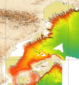
CATALANO-BALEARIC SEA (NW Mediterranean) Bathymetric Chart |


![]()

DATA SOURCES
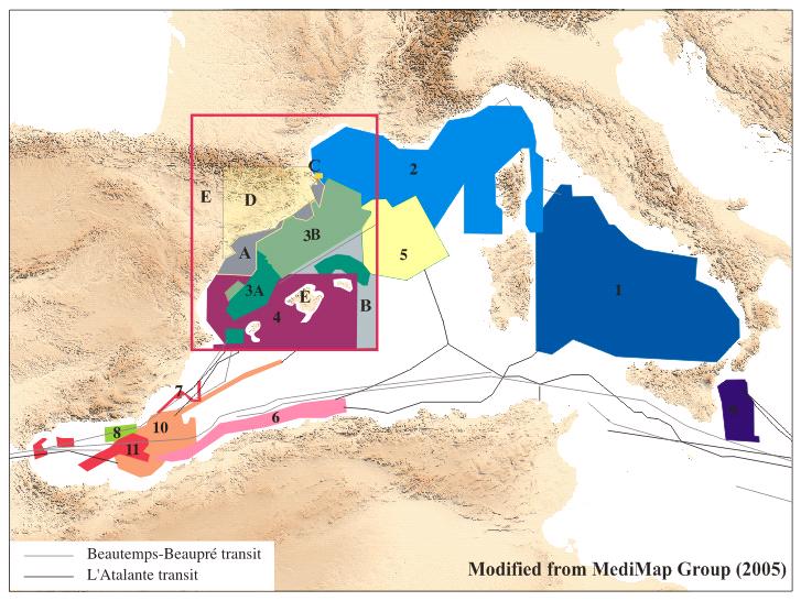
MEDIMAP GROUP (**) Multibeam data:
(Grey references: not used in
this sinthesis)
| 1: Digital Terrain Model from Sezione Geologia Marina, ISMAR Istituto Scienze Marine, Bologna |
| 2: Digital Terrain Model from Ifremer Geociènces Marines, Brest. "Bathymetric summary of multibeam data (Western Mediterranean)", Editions Ifremer, 1998. Le Golfe de Lion : Carte Morpho-bathymétrique", Edition Ifremer, 2004 |
|
3A : Digital Terrain Model from GRC en Geociències Marines, Universitat de
Barcelona. and Institut de Ciències del Mar (CSIC). Data from R/V Hespérides in the frame of HC
& Mobility Programme European Access to Sea Floor Survey Systems-IOS. 3B : Digital Terrain Model from GRC en Geociències Marines, Universitat de Barcelona EC FPV and FPVI projects, Eurostrataform, Eurodelta and Eurodom, ESF Eurocores pro, West -Med and Spacoma, amd Spanish RTD projecs Grandes and Prodelta. |
| 4: Digital Terrain Model from Multibeam Mapping Group, Instituto Español de Oceanografía, Madrid. "Mapa batimétrico del Mar Balear y Golfo de Balencia, Mediterraneo Occidental", Ediciones del Ministerio de Ciencia y Tecnología, 2001, ZEE Working Group |
| 5: Progress cruise, R/V Le Suroit, 2003, IUEM/Université de Bretagne Occidentale, Brest, as part of the activities carried out within the EC FPV project Eurostrataform. |
| 6: Marajda Cruise, R/V Le Suroit, 2003, IUEM/Université de Bretagne Occidentale, Brest, and CRAAG, Alger. |
| 7: Digital Terrain Model from Instituto Andaluz de Ciencias de la Tierra, CSIC y Universidad de Granada. |
| 8: Digital Terrain Model from Unitat de Tecnologia Marina, CMIMA/CSIC, Barcelona. Data from R/V Hespérides in the frame of Spanish RTD Project HITS and IMPULS and ESF Eurocores WESTMED |
| 9: Medee cruise, R/V L'Atalante, 1995. Laboratoire de Géologie, CNRS-Insu, ENS Paris |
| 10. Several R/V L'Atalante and BHO Beautemp-Beaupré transit data in the Mediterranean Sea. Obs. Oceanologique de Villefranche sur Mer |
| 11* : Digital Terrain
Model from Inst. de Ciènces
del Mar CMIMA/ CSIC of Barcelona.
Data from R/V Hesperides in the frame of ALBA92 Project. * These areas in the MediMap Group map are wrongly attributed to institution number 7. |
OTHER DATA SOURCES:
| A : Interpolated contours data from FOMAR maps (Inst. de Ciències del Mar-CSIC and IGME), projects: Tortosa, Barcelona and Figueres, published by Ministerio de Industria and other data single beam data from the south of the Ebro Delta. |
| B : Digital Terrain Model from GEBCO Digital Atlas. |
| C : Digital Terrain Model from High resolution Multibeam survey AOA Geophysics and Fugro |
LAND TOPOGRAPHY DATA:
| E::Global 30 Arc-Second Elevation Data Set from USGS (Gtopo30) |
SHORELINE:
EUROSION (CORINE) and ICC, combined
Data Processing:
|
In
September of 2005 IFREMER-CIESM has published the
MediMap group map.
In this map is compiled all the data collected with multibeam echo-sounders
in the Mediterranean sea. The DTM is distributed with the map. This
map is of great interest because reliability and extension,
but is still incomplete for the Catalano-Balearic Sea
area,
except in the zone of the
Gulf
of Lyon.
In order to settle temporarily these blank spaces, corresponding to the
zones of smaller depth, all the existing data in the ICM (of much smaller
reliability) coming from many geophysical and single channel echo-sounder
cruises in the Catalan shelf basically, have been combined with the data
coming from different multibeam sources.
Data from different multibeam sources where combined to create a basic working 200 m cell size grid. This multibeam grid whas combined with others grids created from the digitized contours on the continental shelf. Gebco grided and contours data where used for deep areas.
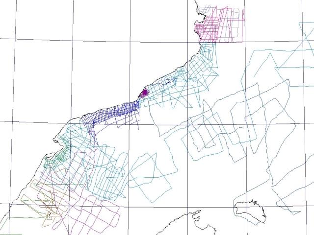
ICM survey lines used to obtain data from the continental shelfs.
|
| A "make-up" was necesary in the contact of diferent sources. This make-up was done removing the worst resolution data (digitited interpolated contours or Gebco data) without removing any multibeam data. The new grid in the blanked area, was created conditioning the anisotropy of the surrounding data values searching. |
| The final grid was finally resampled to get a 1km spacing grid of 700 rows x 545 columns to get the same resolution of the MediMap map considered as public use. |
| Processing has been done with Surfer 8.01 (Golden Software Inc.) |
Grid Geometry
| X Minimum: -0.50036 | X Maximum: 5.7006 | X Spacing: 0.01138 |
| Y Minimum: 38.4496 | Y Maximum: 44.0000 | Y Spacing: 0.00793 |
Datum: WGS-84
| Diferent products where created for the final user : raster maps, pdf maps, contour files in DXF vector format and text files. |
| (*) These data in a 1 km grid are distributed for free use with the MediMap group map. |
REFERENCES: