
|
|
| |||||
| Inicio Antecedentes Objetivos Metodología Bibliografía Enlaces Resultados Documentos | ||||||
| DETERMINACIÓN Y VALORACIÓN DE LOS RIESGOS GEOAMBIENTALES EN EL AREA DE HUNDIMIENTO DEL PRESTIGE (ERGAP) | ||||||
|
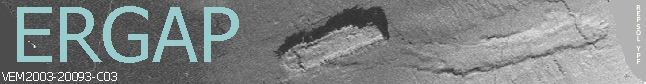
Coordinador: DrŞ Gemma Ercilla (Grupo de Geología Marina del Inst. de Cičncies del Mar, CSIC, Barcelona) RESUMEN: El presente proyecto tiene como finalidad identificar y valorar los riesgos sedimentarios y tectónicos en el área de hundimiento del buque Prestige, mediante el estudio integrado de la morfología, estratigrafía y facies sedimentarias, tipos de fondo, estructuras tectónicas, migración de fluidos, propiedades físicas, geoquímica y geotecnia que caracterizan al sedimento del fondo y subfondo marino; asimismo, tiene como finalidad determinar la posible contaminación por el fuel del fondo y subfondo marino y los procesos geoquímicos actuantes en dicha zona al objeto de valorar el impacto ambiental. El área de estudio comprende la zona de hundimiento del buque Prestige en el banco de Galicia y zonas adyacentes del talud y ascenso continental del margen continental NO de Galicia y de las llanuras Abisales de Iberia y Vizcaya. Para llevar a cabo el citado estudio, el presente proyecto se plantea como un proyecto coordinado integrado por tres subproyectos: subproyecto 1, representado por el Instituto de Ciencias del Mar, CSIC, de Barcelona; Subproyecto2, representado por el Instituto Geológico y Minero de Espańa IGME, en Madrid, junto con la Universidad de Cádiz; y subproyecto 3, que comprende a la Universidad de Vigo, en Vigo. Los resultados del presente proyecto serán transferibles a corto plazo a los sectores de Gobierno, Industria, Defensa Civil y Compańías de Seguro, para organizar lo que se denominan actividades de prevención y preparación, y ayudarán a establecer las condiciones técnicas para aumentar la seguridad de las personas y de las obras civiles que puedan verse afectadas por el vertido del buque Prestige. Asimismo, los resultados podrán ser utilizados por aquellos organismos que se dediquen al estudio de la problemática asociada al pecio y al impacto socioeconómico del vertido que se contempla como prioridad. 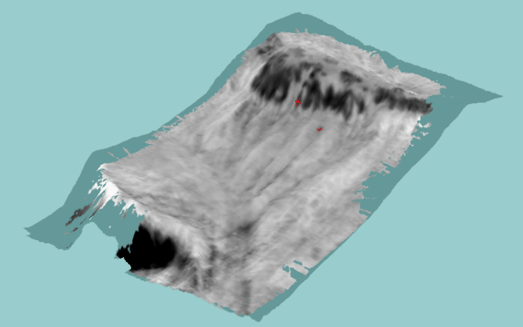 Situación de la popa y la proa del Prestige SUMMARY: The project plans out the tectonic and sedimentary risk assessment in the area of the Prestige sinking through the integrated morphology, sedimentary stratigraphy and facies, seafloor characterization, tectonic structures, fluid dynamics, geochemistry and geotechnics studies of the seafloor and subbottom sediments. Likewise, this project aims to determine the possible contamination of the seafloor and subbottom sediments by oil and the geochemical processes and its products in order to evaluate the environmental impact. The study area comprises the Prestige sinking zone in the Galicia bank and surrounding area of the continental slope and rise, and Iberian and Vizcaya Abyssal Plains. This project is a co-ordinated project comprising three sub-projects: sub-project 1, integrated by the Instituto Ciencias del Mar, CSIC, in Barcelona; subproject 2, integrated by the Instituto Geológico y Minero de Espańa, IGME, in Madrid, joined to the University of Cadiz, in Cadiz; and the subproject 3, integrated by the University of Vigo, in Vigo. Expected results would have short-term implications for the Government, Industry, Civil Defence and Insurance Companies, and they help to establish the technical conditions to increase the security of the persons and engineering works which can be affected by the oil spill event. Likewise, the results will have a great interest for those institutions dedicated to study the problems posed by the Prestige vessel and the social and economic impacts included as priority. |